The Role of Satellite Imagery in Identifying and Assessing Mineral Potential
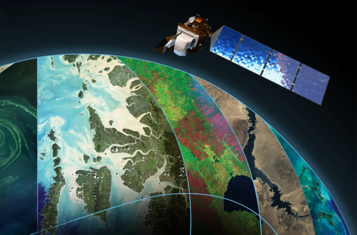
The mining industry has consistently leveraged advanced technology to enhance the efficiency and accuracy of its operations. One of the most transformative technologies in recent years is the use of satellite imagery. This technology plays a central role within exploration in that they define the likely minerals’ potential offering an essential input to the process. From initial reconnaissance to detailed exploration, satellite imagery plays a crucial role in the mining industry. In this article, the different methods of mineral assessment with focus on satellite imagery are outlined. Here Active and passive methods, multispectral and hyperspectral imaging, thermal imaging and identification of different geological features will be described. Also, we will look at ways of improving the inputs of diverse data for both GIS-based analysis and predictive modeling to support better mineral potential assessments. Real-case studies from Iranian mines and mines of other countries are also included to offer an idea about the applications of satellite imagery in modern mining operations. By providing detailed views of surface mineralogy and topography, satellite imagery has been instrumental in optimizing resource extraction and reducing the environmental impact of mining.
Identification Methods and Potential Analysis
The identification and assessment of mineral potential are the cornerstones of any successful mining projects. This phase, more so with the aid of high-quality satellite imagery, set the foundation for all the subsequent exploration activities. Techniques such as multispectral and hyperspectral imaging allow precise identification of mineral spectral signatures, while thermal imaging detects temperature-related anomalies, facilitating the discovery of potential mineral zones. Other enhancement comes from structural analysis and geomorphological surveys revealing specific geological features in these target areas. Therefore, the inclusion of multiple and heterogeneous data improves the predictive value of assessments regarding mineral potentials using machine learning and AI implemented in a GIS environment. These technologies help maintain constant surveillance and regulation of exploration places so there is improved use of assets and lower expenditures than with conventional practices. The combination of these modern methods in the end enhances the effectiveness, precision and environmental sustainability of the mineral exploration.
1. Techniques for Mineral Identification
1.1.1 Broad Geographic Coverage: Satellite imagery offers extensive and accurate geographic coverage of areas which makes it quite useful in the exploration for minerals. It enables the examination of vast, often inaccessible regions, reducing the need for costly ground surveys. For example, Landsat and Sentinel series satellites assist in gathering data useful for mapping large areas containing geological formations and alteration zones that are prospective for minerals. This wide-spread coverage helps geologists to identify areas with high prospects of containing minerals in the shortest time possible, guiding more focused and detailed on-the-ground investigations.
1.1.2 Initial Scanning: High-resolution satellite images and spectral data are crucial for the initial scanning of large land tracts. Instruments like ASTER (Advanced Space borne Thermal Emission and Reflection Radiometer) capture detailed surface characteristics, revealing color anomalies and specific geological formations associated with mineralization. This results in enhanced data resolution and detail which make it possible to identify surface features that might indicate underlying mineral deposits to guide searchers to the general area that ought to be explored in-depth.
Geological Survey
Geological surveys are fundamental to the mining industry, serving as the bridge between the initial identification of potential mineral zones and the detailed exploration necessary to confirm their value. These surveys comprise of the geological interpretation which consists of the establishment of geological status through the examination of geological structures such as stratigraphy and tectonics of the particular area and the geophysical surveys like magnetic, gravity and electromagnetic surveys. The integration of satellite imagery has significantly enhanced the efficiency, accuracy, and depth of these surveys by providing comprehensive data that helps in understanding the geological characteristics of a region. Also, geological surveys help in developing integrated data models and 3D models for conceptual geological structures that are useful in carrying out prediction on mineral deposits as well as to evaluate the level of risk assessment.
1.1 Large-Scale Surveys
1.2 Remote Sensing Technologies
1.2.1 Multispectral and Hyperspectral Imaging: These technologies capture data across various wavelengths of the electromagnetic spectrum, providing detailed information on the mineralogical composition of the earth's surface. They can be used to spot the specific minerals based on their unique spectral signatures. Thus, there is a relevance of hyperspectral sensors, particularly concerning distinguishing one form of minerals from another due to differences in how they reflect or absorb light. This detailed spectral information represents a further stable advancement in mineral identification and mapping that can more effectively guide exploration.
1.2.2 Thermal Imaging: Thermal infrared sensors on satellites detect temperature variations on the earth's surface, which can indicate the presence of certain minerals and geothermal activity associated with mineral deposits. For instance, materials like sulfides emit distinct thermal signatures detectable by thermal imaging technology. This technique is especially helpful in identifying areas with the mineral potential obscured by a layer of material or associated with heat activity, and offers a nondestructive means of exploring for minerals.
1.3 Geological Feature Detection
1.3.1 Structural Analysis: Satellite imagery aids in identifying structural geological features such as faults, fractures, and folds. These structures often control the emplacement of mineral deposits and are crucial for targeting exploration efforts. High-resolution images and digital elevation models help geologists analyze these features in detail, enhancing the understanding of geological settings and improving the precision of exploration activities.
1.3.2 Geomorphological Investigations: By analyzing landforms and surface features using satellite data, geologists can infer underlying geological processes and potential mineralization. Erosional patterns, sediment deposits in rivers, and other surface characteristics provide valuable clues about the geological history and mineral potential of an area. Application of technologies like the remote sensing analysis of aerial photography and digital terrain modeling of exploration areas can be used to enhances the evaluation of existing geomorphological patterns and help determine areas of favorable exploration prospects.
2.1 Integrating Diverse Data Sources
2.1.1 Combining Data Layers: Combining satellite imagery with geological maps, geochemical data, and geophysical surveys enhances mineral potential assessments by creating a comprehensive model of the area. This approach integrates multiple data layers to provide a multi-dimensional view of subsurface geology, increasing the accuracy of assessments. For instance, Landsat-8 OLI and TIRS data have been appropriately applied in demarcating lithological units and structural control which in turn are useful in defining areas of mineralization. These borrowed data sets allow geologists to fashion precise topographic maps that can underscore areas that may contain minerals.
2.1.2 GIS-Based Analysis: Geographic Information Systems (GIS) are essential for managing and analyzing integrated data layers, enabling the visualization of complex datasets. GIS technology helps identify spatial correlations between geological features and mineral deposits, facilitating more accurate predictions. Recent advancements have seen GIS-based 3D geological modeling being used to explore subsurface mineral deposits, which is critical as surface deposits become harder to find. This technology not only enhances the visualization of geological data but also supports more detailed and extensive exploration projects.
2. Evaluating Mineral Potential Using Satellite Data
2.2 Identifying Anomalies
2.2.1 Spectral Anomalies: Spectral data analysis is pivotal in detecting anomalies indicative of specific minerals. Unique color patterns or spectral signatures in satellite imagery often reveal the presence of mineral deposits. For example, with the help of the principal component analysis (PCA) and other digital image processing techniques these are much more distinct and clearer so are easier to filter or rather be more easy to be analyzed. These techniques improve the fine tuning of accordant spectral differences due to mineralization and consequently the drilling processes.
2.2.2 Geochemical Anomalies: Satellite imagery aids in guiding geochemical sampling by highlighting areas where surface anomalies suggest underlying mineralization. These help in enhancing the efficiency and effectiveness of the geochemical surveys because of the targeted approach involved. In this way, by investigating the spectral analysis results and aiming at those regions, geologists can better allocate resources and increase the likelihood of discovering economically viable mineral deposits. This method leverages the spatial and spectral data from satellites to direct on-ground sampling and analysis efforts.
2.3 Predictive Modeling
2.3.1 Machine Learning and Artificial Intelligence: Advanced algorithms and machine learning models are increasingly applied to satellite data to predict mineral potential. These models analyze patterns and relationships within the data to identify high-potential zones. For example, ensemble machine learning approaches using algorithms like random forest, support vector machines, and maximum likelihood classification have shown improved accuracy in mineral prospectively mapping. These facilitate the way through which the various areas that should be explored in detail can be defined systematically based on the data collected.
2.3.2 Conceptual Models: The final product of the potential assessment phase is often a conceptual geological model. This model represents the hypothesized distribution of mineral deposits based on all available data, guiding subsequent exploration activities. Conceptual models are based on geological, geophysical and geochemical data and give a clear idea to understand the mineralization processes. These models are crucial for planning and executing detailed exploration projects, ultimately increasing the chances of successful mineral discovery.
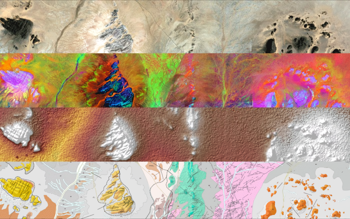
Details of the geological mapping layers for the Western Sahara demonstration area. From top to bottom: Sentinel-2 natural color composite, Sentinel-2 principal components analysis, Shuttle Radar Topography Mission-based elevation and the resulting geological map at 1:50000 scale
1. Determining Geological Status
1.1 Geological Interpretation
1.2.1 Magnetic and Gravity Techniques: Satellite imagery is often combined with magnetic and gravity survey data to provide a more comprehensive understanding of the subsurface geology. These surveys help in identifying variations in the Earth’s magnetic and gravitational fields, which can indicate the presence of mineral deposits. Magnetometer surveys identify changes in the Earth’s magnetic field that trace mineral-containing bodies, while gravimeter surveys depict relative variations in density as a sign of geological objects. These techniques are significant in delineating subsurface geology and defining an area with possible mineral deposits without extensive drilling.
1.2.2 Electromagnetic Surveys: Electromagnetic surveys, supported by satellite data, detect variations in the Earth’s conductivity, helping to locate mineral deposits that may not be visible on the surface. These surveys are useful in defining the ore bodies as it provides information on how the ground responds to the electromagnetic field existing in the vicinity of conductive minerals such as sulfides and oxides. Integration of electromagnetic data with satellite imagery improves the resolution and the structural modelling of the subsurface environment that in turn pave way for focused exploration with reduced impact on the environment due to an effective drilling campaign.
1.2 Geophysical Methods
1.1.1 Stratigraphy: Satellite imagery helps in identifying and mapping stratigraphic units, which are layers of rock with distinct characteristics. Understanding the stratigraphy of an area is essential for reconstructing its geological history and assessing its mineral potential. By analyzing satellite images, geologists can delineate different stratigraphic layers and correlate them with surface and subsurface data to create comprehensive stratigraphic logs.
1.1.2 Tectonic Analysis: Satellite data provides insights into the tectonic setting of a region, including the identification of tectonic boundaries, fault zones, and volcanic features. This information is vital for understanding the processes that have shaped the area and their implications for mineralization. Detailed tectonic analysis using satellite imagery can reveal fault lines and structural deformations, which are critical for locating mineral deposits associated with tectonic activity. This analysis helps in understanding stress regimes and the geological history of an area, aiding in the prediction of mineral-rich zones.
2. Creating Conceptual Geological Models
2.1 Data Integration and Modeling
2.1.1 Combining Data Sources: Satellite imagery is integrated with other geological data sources, such as field observations, geochemical analyses, and geophysical surveys, to create detailed geological models. Consequently, this integration enables provision of a more comprehensive and strategic view of the geology such that, areas that may contain minerals can be easily detected through comparing the surface structures with the subsurface structures. The comprehensive models generated through data integration help in visualizing complex geological structures and predicting the distribution of mineral deposits, improving the efficiency and success rate of exploration programs.
2.1.2 3D Geological Modeling: Advanced software tools allow geologists to create three-dimensional models of the subsurface geology, providing a visual representation of potential mineral deposits and their spatial relationships. These 3D models are useful in evaluating the degree of mineralization, and mapping of appropriate exploration strategies since geometries that are not easily recognized from surface distances are depicted. On the geometric aspect, 3D modeling helps in understanding the geometry and volume of ore bodies, which is crucial for resource estimation and mine planning.
2.2 Predictive Analysis
2.2.1 Modeling Mineral Deposits: Conceptual geological models help in predicting the location and extent of mineral deposits based on the integrated data. These models are essential for planning further exploration and assessing the feasibility of mining operations. Predictive modeling involves using geological, geochemical, and geophysical data to estimate the size, grade, and distribution of mineral resources. This approach refines probable assessment of resources and hedges risks associated with mineral exploration as clearer and more detailed pointer of subsurface geology is obtained.
2.2.2 Risk Assessment: By providing a detailed understanding of the geological conditions, these models help in assessing the risks and uncertainties associated with mineral exploration and extraction. Risk assessment models incorporate various geological, economic, and environmental factors to evaluate the potential success and impact of mining projects. These assessments assist in determining appropriate measures, resources to invest and projects to undertake, and ways of handling the environment while making mining a sustainable and profitable business.
WE ARE KIMIA
Kimia Holding stands as a diversified conglomerate with a strong foothold in various sectors including mining and mineral resources, tourism services, livestock and poultry, agriculture, and foreign trade foreign trade in Iran and across the Middle East. However, it is within the realm of mining that Kimia Holding has truly distinguished itself, garnering recognition for its unwavering commitment to excellence and innovation.
CONTACT KIMIA
Our experts at Kimia Holding eagerly await your inquiries and are prepared to provide insightful answers or address any questions you may have. Should you require further details or wish to share your opinions, please don't hesitate to reach out. Your engagement is valuable to us.
Reconnaissance and sampling are critical steps in the mineral exploration process, playing a pivotal role in the discovery and evaluation of mineral resources. These stages include using and integrating several scientific and technological processes to evaluate the extent of mineral deposit in large vast extensive spectral zones, mostly in the uncharted territories.
Reconnaissance entails a preliminary survey of a large zone with the view of examining areas of interest in more detail. It typically begins with remote sensing techniques, such as satellite imagery and aerial photography, which provide extensive coverage and enable the rapid identification of geological features indicative of mineral deposits. These remote sensing methods leverage advancements in technology to capture signals indicating that there are variations of the surface that might point towards mineral deposits beneath it. For example, the multispectral and hyperspectral imaging allow for collection of data across the different portion of the light spectrum which makes it possible to detect materials through spectral pattern recognition on the basis of their spectral reflectance characteristics of the minerals. In addition to remote sensing, reconnaissance often includes geophysical surveys, which measure variations in the Earth's physical properties. These surveys can provide critical information about the subsurface geology and help delineate potential mineralized zones. Common geophysical methods include magnetic, gravity, and radiometric surveys. As mention before, Magnetic surveys identify changes in the Earth’s magnetic fields due to the presence of ferromagnetic minerals while gravities surveys measures changes of the gravity of the ore which are related to density and ore body. While radiometric surveys, measure natural radioactivity inherent in the minerals including uranium, thorium and potassium.
Sampling follows reconnaissance and involves the collection of geological materials for detailed analysis. There are several types of sampling methods, each suited to different stages of exploration and specific geological settings. Surface sampling is one of the most prevalent techniques and involves the mineral, rock, and sediment samples from the surface. This method is particularly effective for detecting surface anomalies that reflect underlying mineralization. Stream sediment sampling, another widely used technique, involves collecting sediments from rivers and streams. This method was developed with the assumption that all sediments carried by water may include particles originating from mineral bearing deposits upstream hence the possibility of its use in identifying areas with mineral deposits. Another important sampling method is trenching, which involves the excavation of trenches to expose bedrock and collect continuous samples across a mineralized zone. This method allows for detailed mapping and sampling of mineralized structures, providing a more comprehensive understanding of the geology and mineralization. In some cases, drilling may be employed to obtain samples from deeper underground. Drilling methods include core drilling, which retrieves a cylindrical core of rock, and rotary drilling, which produces rock chips and fragments. Core drilling is especially important as it gives specimens that are perfect and unaltered so the geological features and structures of the ground maybe studied in great detail for geological, geochemical, and petro physical analysis.
Reconnaissance and Sampling in Mineral Exploration
Conclusion
The integration of satellite imagery into the mining industry has profoundly transformed mineral exploration and assessment. By combining satellite data with ground-based methods such as geological surveys, geochemical sampling, and geophysical surveys, mining companies can significantly enhance their exploration activities. This comprehensive approach leads to more efficient and accurate identification of mineral deposits, ultimately contributing to the success and sustainability of mining projects.
One of the key advantages of satellite imagery is its ability to cover large geographic areas, including remote and inaccessible regions. This broad coverage allows for the initial scanning and identification of potential mineral-rich zones, guiding more focused on-the-ground investigations. Technologies like multispectral and hyperspectral imaging provide detailed information on the mineralogical composition of the earth's surface, while thermal imaging detects temperature-related anomalies, facilitating the discovery of potential mineral zones. Furthermore, the integration of satellite data with other geological data sources through GIS enhances the accuracy and depth of mineral assessments. GIS-based 3D geological modeling and advanced predictive algorithms powered by machine learning and AI allow for a more comprehensive and precise understanding of subsurface geology. These technologies enable continuous monitoring and management of exploration sites, leading to better resource utilization and reduced costs compared to traditional methods.
As technology continues to advance, the reliance on satellite imagery and its integration with other data sources will become increasingly essential in the field of mineral exploration. The continuous improvement of satellite sensors and data processing techniques will further enhance the accuracy and efficiency of mineral assessments, driving the future success of mining projects. Ultimately, the integration of satellite imagery into mining operations not only supports economic growth but also promotes environmental sustainability by minimizing the need for extensive ground disturbances and improving resource management.
Resources
1. Van der Meer, F.D.; de Jong, S.M.; Imaging Spectrometry: Basic Principles and Prospective Applications, Springer, 2002.
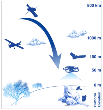
The approach taken to improve mineral exploration. Entailing the use of remote sensing platforms; from satellite, to airborne, as well as field validation with remote sensing and geochemical measurements
The samples taken during the reconnaissance and sampling operations are analyzed using different methods in order to assess the amount of minerals and other geochemical characteristics. These analyses often include assays to measure the concentration of economically important elements, such as gold, copper, and nickel. Additionally, mineralogical studies using techniques like X-ray Diffraction (XRD) and Scanning Electron Microscopy (SEM) provide detailed information about the mineral composition and texture, helping to understand the formation and distribution of mineral deposits. Advancements in technology have significantly enhanced the efficiency and effectiveness of reconnaissance and sampling in mineral exploration. Geographic Information Systems (GIS) and three-dimensional (3D) modeling software allow geologists to integrate and visualize data from various sources, providing a comprehensive understanding of the geological setting and guiding further exploration efforts. Employment of Machine Learning (ML) and Artificial Intelligence (AI) are also being incorporated for analysis of big data and mapping of the potential mineralization zones enhancing the success rate and efficiency of exploration.
Real-World Examples
1. Mines in Iran
1.1 Kimia Mines Company
The Mehdi Abad Zinc Mine in Yazd Province is another prominent example of how satellite imagery has been utilized in Iran. The mine is one of the largest zinc reserves in the world, and satellite data has been crucial in its exploration. Spectral analysis has been employed to detect alteration minerals with regard to zinc deposits and this has helped in mapping of specific areas of interest. The integration of satellite imagery with detailed geological mapping and ground-based sampling has provided a clearer picture of the deposit's potential, leading to more efficient mining operations.
1.2 Mehdi Abad Mine
The Kimia iron ore open-pit mine, located in Kurdistan, incorporates satellite imagery as an aspect helping in the identification of minerals and resources that need to be extracted. Satellite data have proven useful in outlining geological formations and identifying key alteration zones that indicate the presence of iron ore deposits. Spectral imagery, typically in high-resolution from satellites such as Landsat and Sentinel, is useful in studying the surface mineralogy and topography which are important aspects in mineralization. In the case of the Kimia mine, these images have revealed extensive iron ore formations and guided exploratory drilling to optimize resource extraction. Additionally, satellite-based spectral analysis has been employed to monitor changes in vegetation and soil composition, further refining the exploration process.
2.1 Case Study in Andes
2. Mines in Other Countries of the World
In the Andes region, satellite imagery has been instrumental in identifying large-scale copper deposits. By detecting specific geological formations and alterations associated with porphyry copper systems, satellites provide a preliminary indication of potential mineral-rich zones. These initial findings are then validated and refined through ground-based geophysical surveys and geochemical sampling. For example, the integration of satellite data with Induced Polarization (IP) surveys and soil geochemistry has led to significant copper discoveries in countries like Chile and Peru. These methods have not only increased the efficiency of exploration but also reduced the environmental impact by minimizing the need for extensive ground disturbances.
2.2 Australian Outback
In Australia, hyperspectral imaging has proven valuable in the discovery of gold deposits. This technology helps identify surface mineralogical changes that are indicative of underlying gold mineralization. By capturing detailed spectral data, hyperspectral imaging can detect subtle variations in surface materials that correlate with gold-bearing zones. When combined with ground-based field surveys and geochemical analysis, this method enhances the accuracy of exploration efforts. Notably, the integration of satellite imagery with traditional exploration techniques has led to the discovery of significant gold deposits in regions like Western Australia, contributing to the country's mining industry growth.
2.3 Canadian Arctic
In the Canadian Arctic, satellite imagery has been used to locate diamond deposits. The harsh and remote environment of the Arctic makes traditional exploration methods challenging. Satellites, however, can cover vast areas quickly and identify kimberlite pipes, which are indicative of diamond deposits. By using high-resolution multispectral and hyperspectral imagery, explorers have been able to detect the characteristic spectral signatures of kimberlite. Subsequent ground surveys and sampling have confirmed the presence of diamonds, leading to the development of several diamond mines in the region, such as the Diavik and Ekati mines.
2.4 Brazilian Amazon
The Brazilian Amazon, with its dense rainforest cover, presents a unique challenge for mineral exploration. Satellite imagery, particularly Synthetic Aperture Radar (SAR), has been utilized to penetrate the dense canopy and reveal underlying geological structures. This technology has helped in the identification of bauxite and iron ore deposits by mapping the geomorphological features associated with these minerals. The integration of SAR data with geochemical sampling and field investigations has enabled the discovery and assessment of significant mineral resources, supporting sustainable mining practices in this ecologically sensitive area.
2.5 Example in Mongolia
In Mongolia, satellite imagery has played a crucial role in discovering copper and gold deposits in the Gobi Desert. The region's arid and expansive terrain makes ground exploration logistically difficult and costly. Satellite data, particularly thermal infrared imaging, has been effective in detecting mineral alterations associated with hydrothermal systems. These alterations often signal the presence of copper and gold deposits. The use of satellite imagery, in combination with on-site geophysical and geochemical surveys, has led to the discovery of major mining projects such as the Oyu Tolgoi copper-gold mine, one of the largest known copper and gold deposits in the world.
2. Wood, D.; "Geology and Mining: An Introduction and Overview", SEG Discovery, 2018.
3. Davis, J. L.; Reynolds, J. M.; Geophysical Techniques in Mineral Exploration and Mapping, Cambridge University Press, 2019.
4. Zuo, R.; "Geodata Science-Based Mineral Prospectively Mapping: A Review", Natural Resources Research, 29(6), 2020.
5. Liu, Y.; Carranza, E.J.; "Developments in Quantitative Assessment and Modeling of Mineral Resource Potential: An Overview", Natural Resources Research, 31(11), 2022.
6. Multidisciplinary Digital Publishing Institute (MDPI), https://mdpi.com.
7. International Society for Photogrammetry and Remote Sensing (ISPRS), https://isprs.org.
8. NASA Earth Observing System Data and Information System (EOSDIS), https://earthdata.nasa.gov.
Written by Zamin Kavan Company (ZKC)
Which is a subsidiary of Kimia Holding, specializing in the exploration, extraction and processing of diverse mineral resources.
Zamin Kavan Company stands prepared to offer technical and engineering services to stakeholders in the mining industry, encompassing consultation, design and implementation phases.
